To go back and see 2011 Expedition go to: http://bushpilotdhc.blogspot.com/

Sunday, May 14, 2023

NEW BOOK


My book is now PUBLISHED - The WW2 Airplane Crash and my High Arctic Expeditions, available now on Amazon for $12.95 USD - AMAZON LINK - ORDER BOOK

Saturday, November 16, 2019

Boat Place - Episode 1

Join Ron in this debut presentation Episode 1 (YouTube link below), a video traveling on one of his many arctic expeditions. This segment highlights a trip that was undertaken back in the year 2012, flying his DeHavilland Beaver floatplane and landing on an uncharted lake at King William Island, Nunavut. A two mile hike from there to a haunting place in this high arctic region called "BOAT PLACE” - this is the location where a handful of starving English sailors huddled together and slowly froze to death. These were just some of the many doomed crew mates from British Admiralty's Expedition of 1845 led by Sir John Franklin. None ever returned, and not one survived.

After Ron visited this site, he correctly theorized and published in November of 2011 that one of the ships was remanned - based in part on his observations of the live conditions here on the ground at Boat Place, and the fact that the lifeboat's tantalizing final rest position was pointing to the northwest when first found by the initial search party. Indeed, the two ships, HMS Erebus and Terror, were to come to rest on the ocean floor very far apart. Theory published here:
http://bushpilotdhc.blogspot.com/2011/11/location-of-ships-maybe.html

Ron Carlson has spent over 15 years exploring northern parts of Nunavut, spending much of his time surveying areas near and southwest of King William Island, in search of the 2 famous lost ships that long ago departed from Portsmouth England in an ambitious attempt to find the holy grail route of the fabled Northwest Passage. This was to be a journey of destiny. The ships; HMS Erebus and HMS Terror, were ultimately both permanently beset in the shifting arctic sea ice, and from there, all of the 129 officers and crew were then ultimately doomed to endure a very long and suffering fate.
____________________________________________

TO COME - THE BOOK that will be published on the stories of Ron's adventures, dangerous encounters and discoveries, including the chapter describing Ron being the first to discover one of these two famous ships, first in 2011, then again in 2012, as he looked down upon and photographed the silhouette of the wreck, today known to be HMS Erebus, in the calm waters from far above.


Tuesday, November 13, 2012

The little ship Eagle


A little boat I had photographed in Cambridge Bay this last summer, abandoned a while ago.


In doing some digging on this boat, I have come to find out that it was abandoned in 1954 by a famous local priest who had worked with the Inuit of Cambridge Bay, Father Steinman.


He had it originally towed from Tuktoyaktuk (over 200 miles to the east) and it leaked the whole way. Unfortunately he was restationed that same year and this little ship has since not moved. So here it sits, abandoned on the gravel beach, just like the famous Baymaud in the water next to it, a time capsule that is most of the time frozen under ice.


Thursday, August 9, 2012

Churchill Whales

On the way back - Great to see the white whales are still congregating in the Churchill River mouth. Just have to watch the tides and the river current. Landed near the mouth of Hudson Bay and drifted over the belugas.


Then watched the building sized metal buoy zip past me, or I should say, I zipped by it - what appeared to be well over 10 knots by the wake behind that fixed buoy. I knew it was going to miss the plane, but it was the next buoy I was worried about.  

 
Mix the river current with the outgoing tide. Almost got too close to the ocean. The river water was frazzling in a churning high dance at the line where it actually met Hudson Bay.  Had to abort takeoff before I hit that stuff, the plane would not get on the step. I was heavy and the wind must have changed to cross. Took nearly a mile to takeoff upriver, but made it out ok. Scary river. Now I know how people die there. If canoeing across, you would have to start upstream and row 45 degrees up river to make it what is well over one mile across. Otherwise over the breakers and into the open ocean you go.


Avoid the buoys, and especially the dangers beyond.
View looking northeast to Hudson Bay. 

Monday, July 30, 2012

Anomaly?

From 3,000 feet MSL

Close up - Northeast of O'Reilly Island - Islands group
© 2012 - Ron Carlson (Nunavut)

Arctic Mirage to the West

Arctic Mirage
© 2012 - Ron Carlson (Cambridge Bay)

Sunday, July 29, 2012

Polar Bear eats my Video Camera

On my last hike on the coast there on KWI I saw a cluster of seagull activity so investigated to find a small musk ox carcass being fed on by a polar bear.  Also saw a couple of arctic wolves there about too.  Like the prior kit fox video, I was hoping to get some up close video by leaving the camera there.  When I approached within 200 yards the bear ambled off over a nearby rise so I placed the little GoPro camera strategically there and vacated.  When I came back several hours later the camera was gone, with just a couple of plastic shards of it nearby.  I guess attaching a string like the last time wouldn't have helped?

I have seen now how difficult it must have been for the Franklin men to hunt in this particular place,  Except for caribou, which you can approach fairly close (if they happen to be here, I did see very few tracks in the muck flats).  The musk ox herd I videoed saw me one mile away and immediately began to move off once I remained still.  Same with the snow geese.  I was amazed at their eyesight and attention.  Whenever I came over a rise they would immediately waddle away (never fly) from a minimum distance of 1/2 mile away.  I measured it.

Saturday, July 28, 2012

Boat Place

Before I leave this place, had to visit the famous "Boat Place".  It is truly a remarkable spot.  A finger of land jutting out to the ocean, surrounded by brown sandy colored muck tidal flats.  The icepack looming out in the open ocean. I could her the occasional booms of the ice shifting and cracking.  To me it sounded like duck hunters in the distance - shotguns unloading.

As I stood there and looked out in all directions, I could just imagine the desperation and despair.  For me, just after a few days of hiking this land, it is unthinkable to imagine being stuck here for even weeks, let alone months or years.  And here I am hiking and camping in the good weather.  How much suffering did they endure through the winter after leaving the ships?  Unthinkable.

They all must have certainly died here that very first winter, after all leaving the ships for the last - that desperate march towards the Back River.

Pictures and a video of Boat Place below.


The tomb at "Boat Place"
© 2012 - Ron Carlson (King William Island)


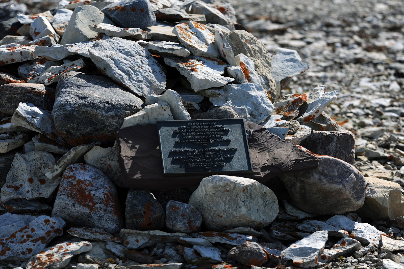
The plaque at "Boat Place"
© 2012 - Ron Carlson (King William Island)


Video - The Tomb at "Boat Place" (click here)

Friday, July 27, 2012

Searching 45 miles of Erebus Bay Coastline - King William Island


The flights east across Victoria Strait from Cambridge Bay on Victoria Island to King William Island in the early mornings, when the weather was stable, was spectacular.


Flying at 3,000 feet MSL eastbound over Victoria Strait to King William Island, 7:00 am.
© 2012 - Ron Carlson (Nunavut)

Landing and parked inland lake on KWI
© 2012 - Ron Carlson (King William Island)


Musk Ox herd near coast of Erebus Bay, KWI
© 2012 - Ron Carlson (King William Island)


Spent the past several days alternating flying and hiking a good part of the southern shore of Erebus Bay, logging about 45 miles on my handheld GPS, zig zagging on foot.  Three seperate locations stood out for further investigations where I observed odd looking wooden objects from the air. 

On my way on the first hike, I found very old two tent rings.  In general, tent rings date as back as old as 800 to 1000 years and up to recent times.  These rings are particularly intriguing because of they are on the Franklin trail.  They are located along the the northern front of a small rocky enscarpment that rises only maybe 5 or 7 feet - and are placed there for a one reason - protection against the wind.  But in reality, there is virtually no protection there, or anywhere here.  One can see though that there was absolute attention paid to topography when they chose this location in an attempt to use any slight edge that the terrain contours might offer.  This edge was practially nill, as it is with almost all the areas around here - very flat with the ocassional boulder.  They are probably Inuit because they are circular.  English patterns were square. 

Tent ring A
© 2012 - Ron Carlson (King William Island)
Tent ring B
© 2012 - Ron Carlson (King William Island)
To get to these, the closest I was able to land was 2.5 miles away inland.  I used two lakes for these puposes.  The average depth was 8 feet with fair water clarity from the air, to avoid bouders and shalows.

This was the routine for shore hiking.  I was not about to land in the ocean and leave the plane with the tides.  The tidal flats are fairly mucky and in some spots, boots sink to lower calfs.  I kept my ankle straps loose on my hipwaders just in case that I would have ro roll out of a bad situation, which almost happened a couple of times.  I found that when my foot would sink deep in a certain spot, my inclination was to accellerate forward, fast - but you have to avoid this.  Best to stop and back track because many times it gets worse.  And then this could possibly happen:
On July 15, 1988, a tragic accident on the mudflats of Turnagain arm near Portage, Alaska claimed the life of newlywed, Adeana Dickinson. She had become mired in the wet silt that is exposed twice every day by the outgoing tide. The ATV driven by her husband had become stuck in the mud and while pushing the vehicle, her leg sunk to her knee. Unable to free her, her husband summoned help, but it arrived too late. The incoming tide rushed in and inundated her. Hypothermia was also a factor as the water was extremely cold.


Here is a picture taken from 300 feet MSL of the typical sand / muck flat on KWI.

Tidal flat, at Erebus Bay shoreline - mid July, 2012
© 2012 - Ron Carlson (Erebus Bay, King William Island)


Below are some pictures of those items.

Subject 1
© 2012 - Ron Carlson (King William Island)
Two finds were more very interesting.  One, a rectanglar column or beam, the other maybe a column or post - definitely man made and definitely old. 
Most intriguing, from my notes from overflights from these same spots last year 2011, these articles were not there then.  They are probbaly new.  I may be wrong - but possibly pushed up by this year's pack ice. 

Or I missed it all last year.


Also some other wooden objects found, one very large, very old and man made.
Detail of subject 1
Had no tape measure, but crudely it is 8 to 9" wide by around 3" thick.
© 2012 - Ron Carlson (King William Island)


Detail of Subject 2
© 2012 - Ron Carlson (King William Island)


Some type of column or post....

Below - It appears that this pole could be part of a mast.  The rope in the middle turned out to be fur and guts from some animal and there were no unusual markings or sign of holes or places where bolts or other attachments could have been.  Have to try to determine what type of wood this might be.  Did not touch or turn over, perhaps there were markings on bottom.


Subject 3 - top end
© 2012 - Ron Carlson (King William Island)
 

Subject 3 - mid length
© 2012 - Ron Carlson (King William Island)

Subject 3 - almost full lenght - lighter exposure
© 2012 - Ron Carlson (King William Island)

Some videos below.